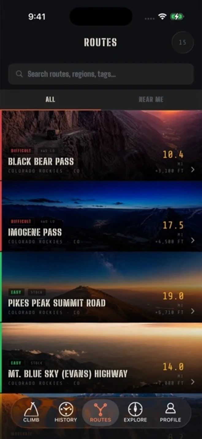
THE PASSES
15 passes. All earned.
Every route was selected for historical significance, driver culture, or raw terrain challenge. No sponsored placements. No algorithmic rankings. These are the roads off-road drivers actually talk about.
DIFFICULT
4WD-LO
Black Bear Pass
Colorado Rockies · CO
One of Colorado’s most famous 4WD roads. The descent into Telluride is a series of shelf roads with near-vertical drops. One-way downhill from the summit.
10.4MI
+3,100FT GAIN
12,840FT PEAK
DIFFICULT
4WD-LO
Imogene Pass
Colorado Rockies · CO
The premier San Juan Mountains pass. Connects Ouray to Telluride via one of Colorado’s highest jeep roads at 13,114 ft.
17.5MI
+4,500FT GAIN
13,114FT PEAK
EASY
STOCK / 2WD
Pikes Peak Summit Road
Colorado Rockies · CO
America’s Mountain. Fully paved to the 14,115 ft summit — accessible to stock vehicles. Race course for the legendary Pikes Peak International Hill Climb.
19.0MI
+6,710FT GAIN
14,115FT PEAK
EASY
STOCK / 2WD
Mt. Blue Sky (Evans) Highway
Colorado Rockies · CO
Highest paved road in North America. Connects Idaho Springs to the 14,271 ft summit of Mt. Blue Sky. No 4WD required.
14.0MI
+7,000FT GAIN
14,271FT PEAK
MODERATE
4WD
Fins & Things
Desert Southwest · UT
Classic Moab slickrock trail weaving through sandstone fins with dramatic views of the La Sal Mountains and Kane Creek Canyon.
8.2MI
+780FT GAIN
4,600FT PEAK
DIFFICULT
4WD-LO
Hell’s Revenge
Desert Southwest · UT
Moab’s most technical slickrock. Deep ledges, near-vertical climbs, and the iconic Hot Tub — a sandstone bowl that swallows rigs.
6.8MI
+650FT GAIN
4,700FT PEAK
MODERATE
4WD
White Rim Road
Desert Southwest · UT
The definitive multi-day 4WD adventure in Canyonlands. 100 miles of canyon rim road at 5,000 ft with the Colorado River below. Permit required.
100MI
+5,200FT GAIN
5,600FT PEAK
DIFFICULT
4WD-LO
Rubicon Trail
Sierra Nevada · CA
The most famous 4WD trail in North America. Granite boulders, steep ledges, and water crossings through the El Dorado National Forest.
22.0MI
+2,800FT GAIN
7,030FT PEAK
EASY
AWD / HIGH CL.
Mojave Road
Desert Southwest · CA
Historic Native American and fur-trapper trade route across the Mojave Desert. 140 miles from the Colorado River to Needles, CA.
140MI
+3,200FT GAIN
4,956FT PEAK
MODERATE
4WD
Magruder Corridor
Pacific Northwest · ID
Remote 101-mile corridor through the Selway-Bitterroot Wilderness. Some of the most isolated forest roads in the lower 48.
101MI
+7,800FT GAIN
8,200FT PEAK
EASY
STOCK / 2WD
Hurricane Ridge Road
Pacific Northwest · WA
Paved road to Hurricane Ridge in Olympic National Park. Sweeping views of the Olympic Mountains and the Strait of Juan de Fuca.
17.0MI
+5,230FT GAIN
5,242FT PEAK
EASY
AWD / HIGH CL.
Talimena Scenic Byway
Southern US · OK / AR
Ridge-top drive along the Ouachita Mountains crest between Mena, AR and Talihina, OK. Fall foliage destination for overlanders in the South.
54MI
+3,800FT GAIN
2,660FT PEAK
MODERATE
4WD
Hatfield-McCoy Backbone Trail
Appalachians · WV
West Virginia’s premier multi-day off-road trail system. The Backbone connects multiple trail systems across Logan and Mingo counties.
78MI
+9,400FT GAIN
3,482FT PEAK
EASY
STOCK / 2WD
Trail Ridge Road
Colorado Rockies · CO
Highest continuous paved road in the US. Rocky Mountain National Park’s main artery crosses the alpine tundra at over 12,000 ft.
48MI
+4,400FT GAIN
12,183FT PEAK
EASY
AWD / HIGH CL.
Cascade Lakes Scenic Byway
Pacific Northwest · OR
Loops past 15+ alpine lakes in the Deschutes National Forest including Sparks, Elk, and Cultus. Mixed paved and unpaved surfaces.
66MI
+2,900FT GAIN
6,350FT PEAK